DEFINING AND IDENTIFYING THE THINGS ON WHICH WE WORK AND PLAY
Nancy Weinheimer, University of Wyoming
Nancy Weinheimer, University of Wyoming
Thinking about the critical zone, and especially from the Bedrock Critical Zone Network’s perspective, three different layers form the foundation that we study (and live upon!). These layers include the bedrock, saprolite, and soil that interact with everything going on at Earth’s surface (i.e., water infiltration, wind, plant and animal growth, plant and animal decomposition, etc.) and contribute to life-sustaining processes.
Each layer has a unique structure and function. For example, bedrock is solid and hard while soil can have a variety of structures and be extremely soft. Understanding the roles and connections between the different layers above and below the surface is important for solving problems regarding soil and water sustainability and improving the way we utilize and care for different ecosystems.

The BCZN uses observations and models to study the formation of and interactions between bedrock, saprolite, and soil to improve our understanding of the critical zone.
How do we identify each layer and what goes on in each of them?
Bedrock
Bedrock is the solid, intact part of Earth’s outermost crust that is often considered the deepest part of the critical zone - it can be exposed or concealed at the surface. In steep landscapes, such as the Rocky Mountains of Colorado, bedrock is commonly exposed at the surface, visible as sheer cliffs or barren peaks. In flatter landscapes, the bedrock can be buried beneath inches to hundreds of feet of unconsolidated material such as soil and saprolite.
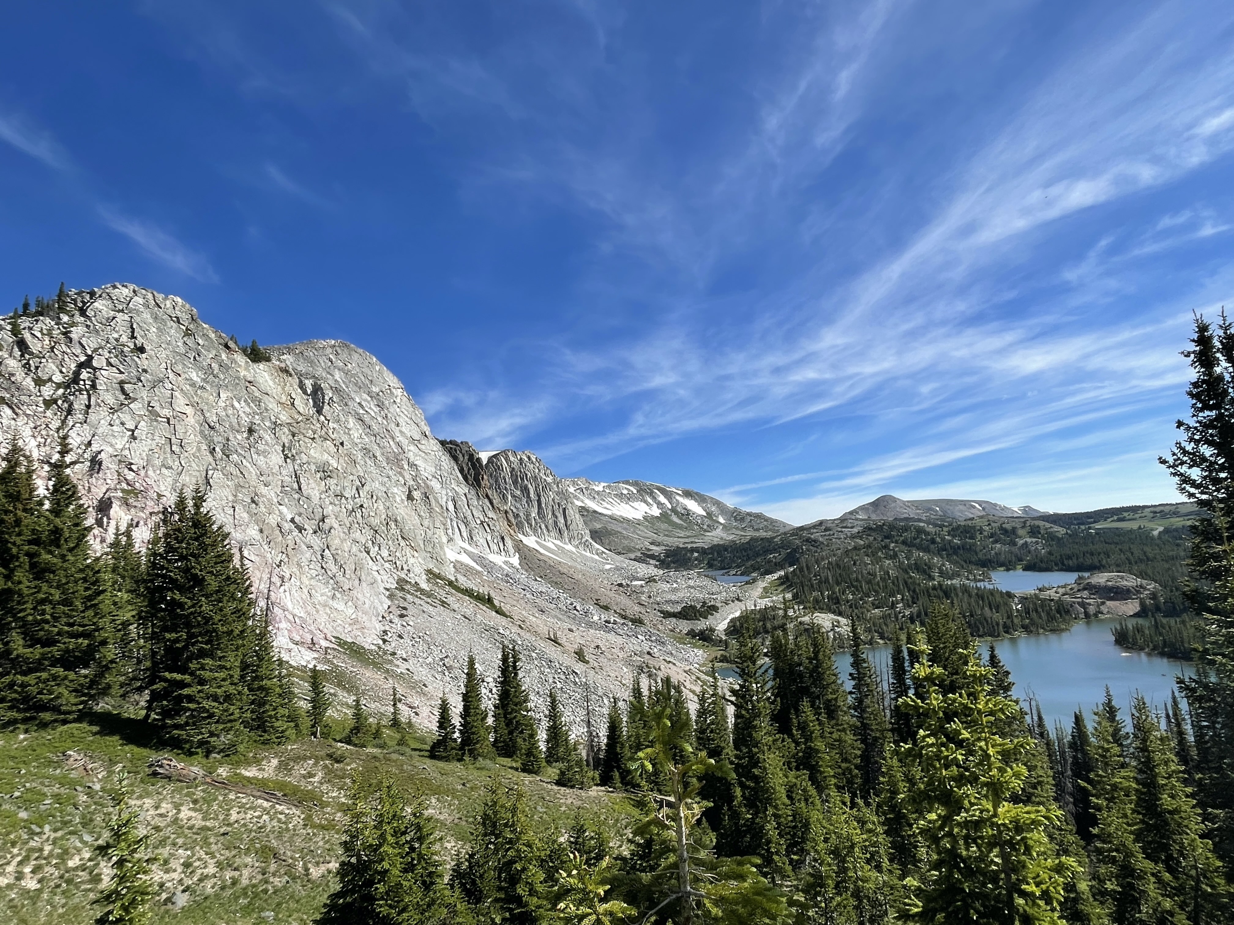

Bedrock that can and cannot be seen at the surface is important for sustaining life. In addition to many factors that make up an ecosystem, such as the climate, the composition of bedrock can influence the ecosystem’s productivity. For example, bedrock that contains more plant-essential nutrients, such as phosphorus, can support ecosystems containing the largest trees on Earth while bedrock lacking such nutrients might not be able to sustain much vegetation at all (Hahm et al., 2014). Understanding bedrock structure and composition is crucial for various industries, including infrastructure construction and mineral extraction.
In the field, we can identify bedrock at the surface and deep below the surface. Like I mentioned before, at the surface it is common to see bedrock exposed as cliffs and peaks, but it is also common to see bedrock exposed along streams or in hillsides that were blasted to build roads. You can tell it is bedrock because it is hard and intact, unlike soft saprolite and soil. Below the surface, we cannot see the bedrock with our eyes, but we can “see” where it is with geophysical techniques, such as seismic refraction. We do seismic refraction surveys by swinging a sledgehammer on a metal plate to send waves into the subsurface and measure the speed at which the waves are reflected back to the surface. The speed at which these waves move through the subsurface structure tell us about how consolidated the subsurface material is– faster waves may indicate that the material is more solid, like bedrock.
Saprolite
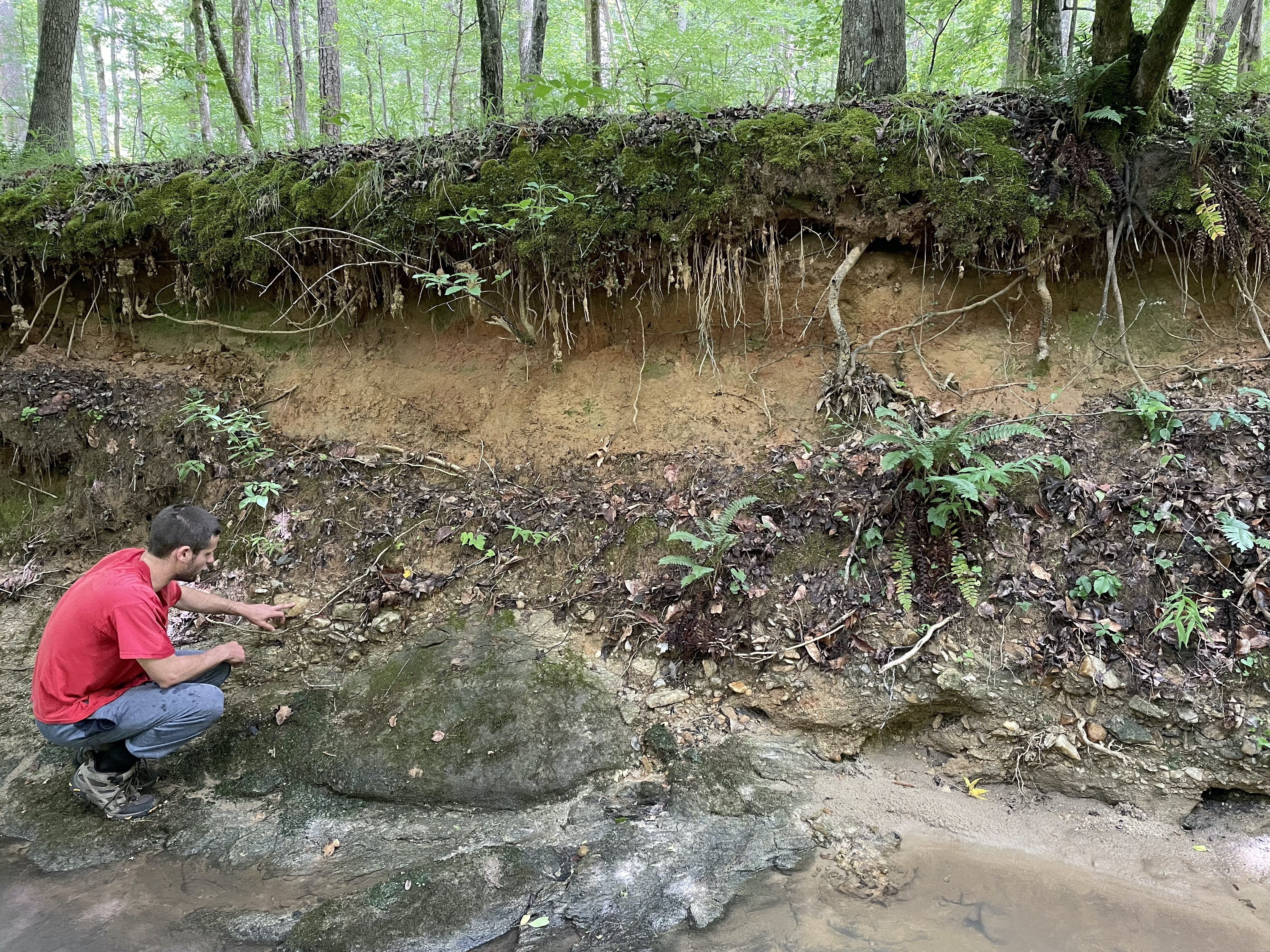
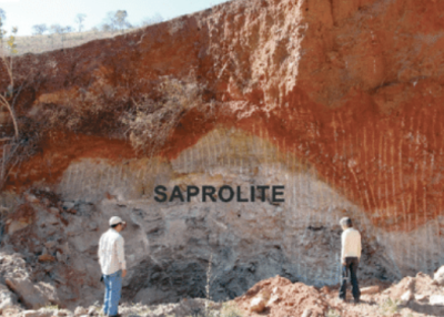
Saprolite is chemically weathered or “rotten” rock that forms from and sits on top of intact bedrock. While most of the saprolite layer might be loose grains of broken down bedrock, it is common to find chunks that maintain the structure of the original rock. You can tell these chunks are saprolite and not individual rocks or sections of bedrock because you can easily break them up with your hands or a shovel. This remnant structure is the tell-tale sign you have saprolite that hasn’t become soil yet.
Saprolite can be significantly less dense than bedrock while maintaining a similar structure because of the fine-scale network of material breaking down within fractures and weak points. The porous structure of saprolite allows significant water and air flow, which enhances the weathering processes that turn saprolite into habitable soil with plant-accessible nutrients. Since saprolite is typically sandwiched between the parent bedrock and developed soil, it is not as commonly visible at Earth’s surface– although sometimes it can be seen in places without much soil and vegetation cover, like the Sierra Nevada mountains. In the way we image bedrock underground, we are also able to “see” saprolite with seismic waves because it is much softer than bedrock and so the waves travel much slower through it.

Soil
Soil, the uppermost layer, develops as a result of the breakdown of rock (releasing minerals and nutrients) and decomposition of organisms (releasing other nutrients and gasses) through a variety of processes– many people know it as “dirt”. The mixture of rock-derived nutrients, organic material, and environmental factors creates the perfect foundation to sustain life.
Depending on the climate, organisms, topography, and bedrock composition, soils can be inches to thousands of feet deep. The relationships between these factors and most importantly the minerals of the original parent rock allow soil to be almost any color you can imagine. Iron oxides enable a variety of warm colors – reds, oranges, yellows, and even purples. Other minerals like chlorite and olivine cause green hues, while vivinite can create a shade of blue. Most common materials, such as salts, volcanic ashes, organic matter, reduced iron, and magnetite lead to the array of whites to browns to blacks we see the most.
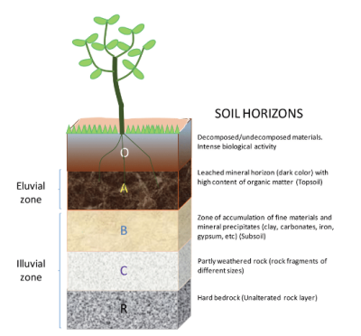
Soils tend to be even more porous and unconsolidated than saprolite, allowing a higher capacity for holding and transmitting solids, liquids, and gasses. Not only do the plants and animals that live in soil contribute to the loose structure, but the flow of water and nutrients in turn sustain them. While most fertile soil is significantly mixed by activity such as trees rooting and animals burrowing, distinctive layers called horizons will often emerge. Horizons (i.e., O, A, E, B, and C) are characterized by their unique appearances, structures, compositions, and processes. For example, the E horizon is often characterized by the leaching of components like iron oxides, clays, organic matter, and salts, whereas the B horizon is identified by the accumulation of these components. You might be familiar with an image of soil horizons such as the one below.


Reference
Hahm, W. J., Riebe, C. S., Lukens, C. E., & Araki, S. (2014). Bedrock composition regulates mountain ecosystems and landscape evolution. Proceedings of the National Academy of Sciences, 111(9), 3338–3343. https://doi.org/10.1073/pnas.1...
Mikhailova, E. A., Zurqani, H. A., Post, C. J., Schlautman, M. A., & Post, G. C. (2021). Soil Diversity (Pedodiversity) and Ecosystem Services. Land, 10(3), 288. https://doi.org/10.3390/land10030288